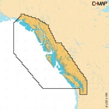
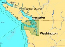
C-MAP Reveal Coastal British Columbia and Puget Sound
$286.00
(Available - Call for Info 877-999-3699)

C-MAP Reveal Coastal British Columbia and Puget Sound
C-MAP M-NA-Y207-MS Reveal Coastal British Columbia and Puget Sound
Model: M-NA-Y207-MS- Shaded Relief — bring the world around you to life, with 3D rendered land and underwater elevation — including areas of Ultra-High-Res Bathy seafloor imagery,... Read More...
SKU: #355661632861741 | Model: #M-NA-Y207-MS